Trip begins a week from Friday AK to AL
Thu, 04/01/2010 - 11:36pm
|
16 years
|
We did it 2 years ago in reverse and a slightly different route in 23 days. Lots of stops for enjoyment. This time it will be a 13 day trip, and with an end goal in mind, so a much faster trip.
http://i61.photobucket.com/albums/h44/trudy_w/map2.jpg
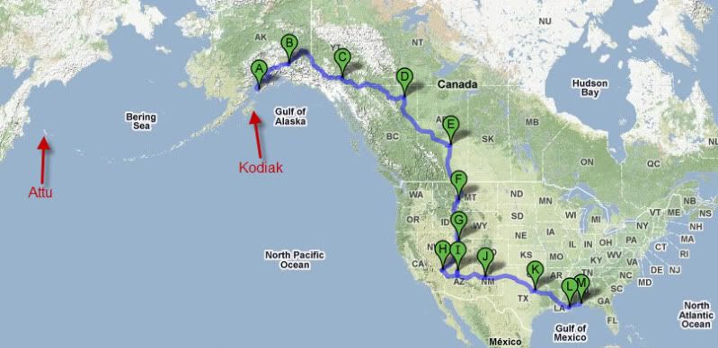
Going to try the red light camera DB for the trip and see if I see anything in the few cities covered that we'll pass through. Garmin 760 will be on the dash.
It will begin with an overnight ferry trip from Kodiak to Homer AK, then the drive begins.
5664 miles, 102 hours of driving time
That should be a nice trip
That should be a nice trip with lots of nice scenery.
Charlie. Nuvi 265 WT and Nuvi 2597 LMT. MapFactor Navigator - Offline Maps & GPS.
Wow
Now *that's* a road trip!
Looks great
I would pick up a copy of the Milepost before leaving Alaska. Even your 2 year old copy would be good for info along the ALCAN.
As to other POI, pick up Ride-To-Eat.GPX, Rest Areas, and a couple of the Restaurant chains. I recommend Marie Callendar's for west of the Mississippi, Bob Evans and Cracker Barrel on the east. Of course, while in Canada you'll need Tim Horton's of course. If I remember right, A&W is also big in Canada.
Please keep us informed of your progress, and one more thing - keep a notebook so you can write down some of the interesting places you visit and some of the better food and hotels. It would be a great POI list for someone that may be planning the trip later.
ɐ‾nsǝɹ Just one click away from the end of the Internet
Destination?
Where are you coming to in AL?
AK to Key West, FL?
Heck, you might as well continue past Alabama and travel the whole length of Florida down to Key West. (Now THAT is a road trip!!!)
-Dave
Extra thousand miles on route?
Per my calculations, the driving distance from Homer AK to Orange Beach AL is "only" 4,634 miles, which is about a thousand miles less than the distance stated in the original post. What route are you taking that would involve a thousand-mile detour?
(BTW, I picked Orange Beach as an example since it is on the Gulf shore, and thus would be one of the further Alabama cities from Alaska.)
Look at his planned route
Per my calculations, the driving distance from Homer AK to Orange Beach AL is "only" 4,634 miles, which is about a thousand miles less than the distance stated in the original post. What route are you taking that would involve a thousand-mile detour?..
I repeated your calculations and came up with a similar result, but that is the most direct route. If you look a the link to his map it looks like he's going by way of Las Vegas and the Grand Canyon. That adds to the distance, but also to the enjoyment.
"There's no substitute for local knowledge" nüvi 750, nüvi 3597
Headed to Robertsdale, and
Headed to Robertsdale, and not the most direct route. Going to see family in Vegas, doing Grand Canyon, and a few other stops. Was originally was about 6255 when we had a stop in Yosemite National Park in there (wife wanted to see big trees) but that and got canned along with Phoenix and Salt Lake City to save a few days on the trip. Our new house didn't close last week when we were down there, so now we need to be there a bit sooner.
We have the Milepost from 2 years ago, we didn't find it all that useful, and we have a journal from that trip as well that we will be continuing. We counted Wal-Mart trucks on the way up (NY to AK) and the total was 123. Might add in UPS and FEDEX trucks this time lol
I done a file on Places To
I done a file on Places To Visit http://www.poi-factory.com/node/24720 that may have some stops you would be interested in.Any new locations you document on your trip and would like to add let me know.
I done that cross country trip a few years ago from VA to CA and really seen some beautiful scenery.Planning to do it again in June.
Charlie. Nuvi 265 WT and Nuvi 2597 LMT. MapFactor Navigator - Offline Maps & GPS.
Milepost
We had the milepost when we first drove the Alcan from Anchorage to Portland and back in 1953. Drove it again, from Anchorage to DC this time and did it without the MP in 2004. The best use we found was looking up interesting places that were along the route each night and then ticking them off when we passed. The MP used to give reviews of some of the lodges and motels along the way and pointed out the locations of the Provincial parks.
Of course the road changed a lot in 51 years, but it was fun stopping in some of the places we had stopped back in '53 and telling them about the last time I was there.
I don't know what time you will be getting started, but be certain the tank is full when leaving Tok. Gas prices are considerably higher in Canada. We enjoyed a "last meal" at the Tok landmark, Fast Eddies and the next one was just outside Sweetgrass which is on your route. The big mall in Calgary is worth stopping at. Prices for meals were very reasonable. Muncho Lake is also a good place to eat, but it can be a little in the pricey side depending on your budget. But by that time you will be ready for a really good meal after all the fast food and diners.
It might be best to plan on staying in Tok overnight and heading out in the AM from there. This will let you hit Canadian Customs late morning to around noon.
ɐ‾nsǝɹ Just one click away from the end of the Internet
Quick Run Through Alberta
It looks like you will be passing through Alberta fairly quickly. Too bad, because you will miss my hometown in the Valley of the Dinosaurs.
You 'll be coming down from Grande Prairie to Edmonton on what is known as "Moose Alley". There will be a lot of critters moving about in mid-April and they don't have a POI file for the big ones! Drive carefully.
Gas in Alberta is running around $3.60 for an American gallon right now. And I think the "big mall" a_user mentioned is actually the West Edmonton Mall. Of course, he could be referring to the new Cross Iron Mills mall on the northside of Calgary, just off the highway. There is a lot of radar on Highway 2 through Calgary. And remember, Canada is in kilometers per hour!
I hope you have a safe and fantastic trip!
We are headed out of AK and
We are headed out of AK and Canada as fast as possible lol
AK because we really can't stand it any longer, and Canada due to lodging costs. Once we hit the lower 48, we slow down a bit to enjoy.
Went through our journal from 2 years ago a bit. Lots of stuff written was things to google when we got to a hotel with a net connection
Hotels in Alberta
AK because we really can't stand it any longer, and Canada due to lodging costs. Once we hit the lower 48, we slow down a bit to enjoy.
Lots of stuff written was things to google when we got to a hotel with a net connection
I have to admit, hotel costs out here are REALLY high... and I can't figure a reason for it!
If you're looking for comparatively inexpensive lodgings in Grande Prairie or Leduc (just south of Edmonton), I recommend the Western Budget chain. I have stayed in this chain in both places and, although the rooms are quite basic, they're clean and comfortable. Google "Western Budget Motel".
wow
That's quite a drive down south. Have a safe and fun trip!
one step closer. The house
one step closer. The house was packed up and loaded Mon-Tues. 2 more nights to go.
Robertsdale, Alabama
Be careful in Robertsdale. There's usually a speed trap on Highway 59 northbound where it splits going north near Florida Street. The speed limit changes quickly, without notice and there is often a police cruiser with radar in the curve. You can't see them until it's too late.
Great trip!
Can you post your progress on POI Factory?
“It’s their world. We’re just living in it.”
Thanks for the speed trap
Thanks for the speed trap tip!
I'll try to post our progress when we have net connections in the hotels.
Have fun
Have fun!
Bring back pictures.
dconsolla, I was in KW
dconsolla, I was in KW 1992-1996. I drove there from Petaluma CA, and when I left flew from there to Hilo Hawaii! Seems all my moves are across the continent or more lol
From Hawaii back to South Florida, Stuart area in 1998.
End of Day 1 Driving (day 2
End of Day 1 Driving (day 2 overall)
Last night Ferry from Kodiak to Port Lions to Homer. Arrived about 7:40 this morning.
Unloaded and rolling about 8:30am
553 Miles, Homer to Tok.
The highest gas price we saw was $3.98
Fuel Used 39.5 Gallons
Cost $142.20
Avg MPG 14.82
Might post pics later... long day
Currently staying at http://www.cariboucabins.info/ we stayed here on the way up 2 years ago. Pet friendly as all the places we will be staying at are. Garmin 760 on the dash using the latest maps 2010.4 it has the lodge address on the wrong side of the intersection, about a mile off. Has the street right this time. In 2008 it had no idea where the street was.
Driving
So - what are you driving?
Garmin StreetPilot c580 & Nuvi 760 - Member 32160 - Traveling in Kansas
2003 Dodge Ram 1500 QC, with
2003 Dodge Ram 1500 QC, with about 250# of dog (2 Greyhounds and a Doberman in the back seat, wife and I up front, and the bed full to the top of the cover. Weighted down pretty good.
Not to lead you elsewhere,
Not to lead you elsewhere, my wife and I posted pics near the bottom of this page http://forum.greytalk.com/index.php/topic/252689-departure-c...
I'd post them here, but I don't think images open remotely here.
nice pictures
nice pictures... and you took.. "cruise"?
ferry
Thank you
For sharing the photos and allowing us to accompany you on your journey.
"There's no substitute for local knowledge" nüvi 750, nüvi 3597
pics
Awesome pics. Went on an Alaskan cruise @ 4yrs ago, beautiful scenery.
All the worlds indeed a stage and we are merely players. Rush
Kodiak is an island, you
Kodiak is an island, you can't drive there. We had to take a ferry from Kodiak to Homer to get to the mainland where we could drive from
http://pics2.city-data.com/city/maps/fr5144.png
Time to shower and head out. Today will be a longer day...
link dont work.
http://pics2.city-data.com/city/maps/fr5144.png
403 Forbidden
Jerry...Jacksonville,Fl Nüvi1450,Nuvi650,Nuvi 2495 and Mapsource.
Heavy
2003 Dodge Ram 1500 QC, with about 250# of dog
Whoa!!
(2 Greyhounds and a Doberman
Ah, thanx for clearing that up.

in the back seat, wife and I up front, and the bed full to the top of the cover. Weighted down pretty good.
Quite the load.
The Wizard of Ahhhhhhhs - Earned my Windmill 4/12/2010
key west
dconsolla, I was in KW 1992-1996. I drove there from Petaluma CA, and when I left flew from there to Hilo Hawaii! Seems all my moves are across the continent or more lol
From Hawaii back to South Florida, Stuart area in 1998.
I lived in the Miami area (Sunny Isles Beach) for about two years, yet only made it down to Key West once. It's amazing that despite being in southern Florida, I was still a three-hour drive away.
Have a ...
safe trip, and enjoy yourselves!
"Backward, turn backward, oh time in your flight, make me a child again, just for tonight."
More pics added from
More pics added from yesterday and today http://forum.greytalk.com/index.php/topic/252689-departure-c...
The Garmin Maps (2010.4) don't display the speeds throughout the ALCAN in Canada though they do take them into account in the arrival time. We have found that for any speed under 100km/h the Garmin estimates them much less, ie. we make up a good bit of time doing the speed limit in 80-90km/h areas, but when we are in a 100km/h area, we meet the estimates.
It seems like 95% of Canada is closed up here, so don't count on any fuel stops listed, or even advertised on the side of the road for that matter. Unless you are in a larger town, everything is closed up for the season. Paid $6.64 per gallon for gas today!! Staying in Dawson Creek BC for the evening. The end of the ALCAN.
Looks like more Caribou on
Looks like more Caribou on the road then cars.
Charlie. Nuvi 265 WT and Nuvi 2597 LMT. MapFactor Navigator - Offline Maps & GPS.
We said today, we definitely
We said today, we definitely saw more buffalo than cars!
Free Roaming Animals
Great pictures With the size of those bison, I would not want to encounter one on the road at night!
Once you get into Alberta you will be seeing a lot more traffic, most likely in the form of rig crews. Drive safely and remember to take rst breaks both for yourself and the dogs.
Caribou aren't big spenders
... The Garmin Maps (2010.4) don't display the speeds throughout the ALCAN in Canada though they do take them into account in the arrival time... It seems like 95% of Canada is closed up here...Paid $6.64 per gallon for gas today!!...
I have a nüvi 750 and it is my understanding that the speed limit display is part of the map data base for selected roads in the U.S. Maybe one of our Canadian friends can confirm whether the speed limit displays anywhere in Canada. Be happy that your model includes roads in Canada, a few do not and that came as a rude surprise to a friend who recently flew to Anchorage to help his son drive back to Texas on a PCS move. He said he had a blank screen about an hour out of Tok. Good thing paper maps are still available.
The way the ETA is calculated isn't as simple as distance divided by current speed. When a route is calculated, I believe it starts with the stimulation algorithm since it gives you a fairly good eta even if you're not moving. It then constantly refines the ETA based on how your current speed influences the algorithm so as you close in on your destination, the eta will always be on the nose. The "weighted" algorithm might account for why the ETA doesn't fluctuate wildly as the caribou slow you down. Some of the newer models also account for time zone changes, mine does not, so I need to manually select the current time zone. Near the bottom of the 1st page at http://www.poi-factory.com/node/6585is a link to a file listing >1300 timezone points in the U.S. I converted this to a .gpx with an alert to remind me to make the change when I cross a time zone.
The folks along the ALCAN probably do 95% of their business once the RVers hit the road in a couple of months. $6.64/gallon - yikes!!! Round up them reindeer and put them in a harness.
Looking forward to the next installment of your photos.
"There's no substitute for local knowledge" nüvi 750, nüvi 3597
road trip
I love the pics!
I made the trip to the Arctic Circle 2008 on a M/C from Michigan, and then down to Anchorage. then the Tok cutoff to Chicken and across the Yukon to Dawson city BC
I love the roads . . . . Drive safe.
WD
Portage, MI
So many roads so little time.
TXRVer wrote
I have a nüvi 750 and it is my understanding that the speed limit display is part of the map data base for selected roads in the U.S. Maybe one of our Canadian friends can confirm whether the speed limit displays anywhere in Canada. Be happy that your model includes roads in Canada, a few do not and that came as a rude surprise to a friend who recently flew to Anchorage to help his son drive back to Texas on a PCS move. He said he had a blank screen about an hour out of Tok. Good thing paper maps are still available.
I had the same type of problem with my now bricked MIO MOOV, only in reverse, mine only showed major US roads and I only had a CAA trip kit map, so we couldn't stray to far off the route.
All the worlds indeed a stage and we are merely players. Rush
Canada speed limit & roads
Guess I forgot to add that my Zumo 550 worked flawlessly the entire trip. Only parts of the Dalton Hwy were off a bit, and I was blazing a trail on a green screen.
Love the pictures of the dogs !
Travel safe.
So many roads so little time.
Pics from today added
Pics from today added http://forum.greytalk.com/index.php/topic/252689-road-trip-a...
Nasty snow storm south of Calgary really slowed the end of the day down.
The 760 does not take into account current speeds when calculating ETA. As an example today we were stuck at about 25mph for 2 hours, and the ETA kept going back/back/back.
One additional thing, the maps of Kodiak Island (where I was for 2 years) are completely useless. Nearly all of the time the 760 has you off the road, in the water or on a mountain. Off the island they have been really good throughout the ALCAN.
There is a major construction project going on in Edmonton AL and the in/off ramps downtown have been recently demolished and moved, so even with new maps, nothing matches. Pay strict attention to the actual construction road signs in that area.
Any Aurora
There are solar storms in progress and the Aurora are being seen further south.
Might be worth you while to take a look at your night sky.
The Wizard of Ahhhhhhhs - Earned my Windmill 4/12/2010
Winter Storm Warning
Pics from today added http://forum.greytalk.com/index.php/topic/252689-road-trip-a...
Nasty snow storm south of Calgary really slowed the end of the day down.
The 760 does not take into account current speeds when calculating ETA. As an example today we were stuck at about 25mph for 2 hours, and the ETA kept going back/back/back.
Sorry about that! A storm came up quickly through Montana and blanketed southern Alberta. The Montana DoT web site (http://roadreport.mdt.mt.gov/map/) indicates poor driving conditions from the border to Helena. Take care!
Thanks for the link. Wife
Thanks for the link. Wife found that late last night and have been looking at it since. Will definitely delay us a day and/or change our route. Wanted to make it from here 12 hrs south to Salt Lake City, but that isn't going to happen today.
I-15 Through Montana
We have travelled the I-15 down south many times in the last few years. It is a beautiful drive in good weather but can be a real problem at this time of year.
Although the portion from Great Falls to Butte is moutainous and windy, the real trouble during bad weather comes between Butte and Idaho Falls. Monida Pass (at the Montana - Idaho border) can be VERY treacherous in snowy conditions and there are very few towns, ranches or services available.
Take your time and don't push to get a predetermined distance! It's better to travel slowly and get somewhere later than spend time in the ditch
ETA
Pics from today added http://forum.greytalk.com/index.php/topic/252689-road-trip-a...
Nasty snow storm south of Calgary really slowed the end of the day down.
The 760 does not take into account current speeds when calculating ETA. As an example today we were stuck at about 25mph for 2 hours, and the ETA kept going back/back/back.
Maybe I'm misunderstanding what your saying but isn't the ETA getting longer exactly what should happen to the 'estimated time of arrival' if you are going slower than the speed that was used to calculate the ETA in originally?
Nuvi 350, 760, 1695LM, 3790LMT, 2460LMT, 3597LMTHD, DriveLuxe 50LMTHD, DriveSmart 61, Garmin Drive 52, Garmin Backup Camera 40 and TomTom XXL540s.
Just got in to Idaho Falls,
Just got in to Idaho Falls, not Salt Lake City as originally planned for today. We spent 4 hours sitting still on HY-4 this morning. It was closed a few minutes after we got underway and we were stuck just outside Milk River waiting for about 12 vehicles to be pulled from the various snow banks. The stuck vehicles included several snow plows, graders, semi trucks, and private vehicles. It was a mess!
t923347- Yes, the time moves back, but it is not recalculated based on current speeds. It is recalculated based on current position with 'intended' speed. So if I have 60 miles to go, and I am making 20mph in a 60mph zone, my eta will be 60 minutes, not 20mphx60miles or the correct 180minutes.
Saw my first red light POI today, that was cool!
Staying at the Candlewood Suites hotel in Idaho Falls this evening. What a great hotel! Huge nice rooms, free laundry, beverages, kitchenettes, etc. Nicest hotel I have stayed at in quite a while.
The Sunny South
Great to hear you made it to Idaho Falls. You hit the worst part of the storm in southern Alberta but should now be in the sunny South. We had five centimeters of freezing slush but Calgary (90 minutes southwest) had NOTHING... and I just changed out my winter tires!
Hope your trip is much smoother - now you have some time to do some sightseeing!
Interesting. Staying in
Interesting. Staying in Santa Rosa NM tonight, but the Garmin 760 could not find the town to set is as a destination. I wound up setting the destination the next town up, and then using the POI DB to find our hotel "along current route" which does list it as Santa Rosa, then setting that as the destination. Odd...
Not Familiar
Interesting. Staying in Santa Rosa NM tonight, but the Garmin 760 could not find the town to set is as a destination. I wound up setting the destination the next town up, and then using the POI DB to find our hotel "along current route" which does list it as Santa Rosa, then setting that as the destination. Odd...
Not familiar with that area, but I have also found it "wierd" what was in/not in the mapping database. I first thought that some of the unincorporated towns didn't show because they didn't have a post office. Fort Dodge kansas does have a post office, but still wasn't in my maps when I tried to search for the destination with that city name.
Many times I will find cities/towns/blips are in the list of "cities nearby" but not if I am trying to search for a poi destination under states for some reason. In otherwords, the city database is only a list of names with a coordinate point. All the poi's don't use this list at all.
I think it has to do with zip codes. If you were to look at wichita kansas, there are several small towns that have city government, but not necessarily their own post office. You can either use the town name or wichita with the zip and they get the mail. In almost all instances I have found all mapping software uses the large city name, but sometimes then when you actually get there it has the correct small town name in the poi database - but you can't search for it. It is sort of frustrating as the map database I don't think is consistant on this from county to county/state to state. I usually then just search by the name of the poi I am wanting to find to eliminate the problem of trying to find out what city name the poi was put in under.
Please keep in mind that my maps are now a couple years old and new ones may be better. I also notice it less as I have learned better how to get the info I need and work around the "bugs" I perceive in the mapping poi database.
daniel
Garmin StreetPilot c580 & Nuvi 760 - Member 32160 - Traveling in Kansas