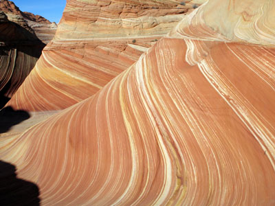
The Wave (on the UT/AZ border East of Kanab, UT)

Login or register to download files
Raw file: The Wave via Wire Pass.csv (1.17 KB)
Includes 18 locations in the following areas:
- United States: AZ
- some may be in: UT (near a border)
This file is for hiking, but the first point is the parking area, so you can use that to get to the beginning of the hike by car. The rest are waypoints to The Wave. It is run by the BLM (Bureau of Land Management) in Kanab. They only let 20 people in a day. 10 by preregistration 3 months (I think) early, and the other ten by draw the day before at their office at 9AM. Weekdays are easier to get than weekends. The hike is through a wash, and up and over a sandy hill, and the rest is primariy slickrock. It is a moderate hike, 3 miles one way. The BLM gives you a map with pictures and coordinates. The wash and Sandy hill are well marked, but the slickrock area is not. A few cairns, but you can see a vertical black slot in the distance once you are on the slickrock for a short distance, and that also marks the destination. It is just above the Wave. Take lots of water.
In the same wash, if you go straight instead of over the hill to the wave, you go on to a slot canyon called Wire Pass, and it ties into another one called Buckskin Gulch.
If there has been rain in the area, the 8 mile dirt road to the Trail Head for both (same place) is impassible. If there is rain, the slot canyons can kill you if you get caught in them. The sides are narrow (hence SLOT) and the walls are high (and wavy), but beautiful. Just plan your trip accordingly.